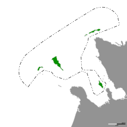
Territory of Kasari Islands
Kasari Islands
Kasari Saared | |
|---|---|
| Territory of Kasari Islands | |
 Map of the Kasari Islands | |
| Country | Slitronia |
| Established | April 11, 2020 |
| Founded by | HGH Johannes I |
| Named for | Kassari island |
| Government | |
| • Body | Imperium |
| Area | |
| • Total | 10.49 km2 (4.05 sq mi) |
| • Land | 0.241 km2 (0.093 sq mi) |
| • Water | 10.25 km2 (3.96 sq mi) 97.71% |
| • Rank | 1 |
| Highest elevation | 2 m (7 ft) |
| Lowest elevation | 0 m (0 ft) |
| Population (2022) | |
| • Total | 0 |
| • Rank | 2-3 |
| • Density | 0.0/km2 (0.0/sq mi) |
| Demonym | Kasarian |
| Time zone | UTC+2 (EET) |
| • Summer (DST) | UTC+3 (EEST) |
Kasari Islands (Estonian: Kasari Saared), officially the Territory of Kasari Islands (Estonian: Kasari Saarte Territoorium), is the largest administrative division in Slitronia. It consists of 6 uninhabited islands and is located north off the coast of Hiiumaa. It was established on 11 April 2021. It covers a total area of 10.491 km².
Etymology
The name of the islands is most probably based on the name of Kassari island, which is located near Hiiumaa.
History
Kasari Islands were originally a planned area for a school group named Khuulide Khuttide Khlubi, which is one of the things Slitronia was based on.
On 30 January 2024, the Slitronian Mapping Institution created a precise sea border for the Kasari Islands. This increased the area from the previous loosely defined territory from 4.54 km² to 10.49 km².[1]
Territory status
Since the whole area of the Kasari Islands is uninhabited, it has been given a special territory status, meaning, that it is still its own administrative area, but instead of a local government, it is governed by the government directly.
Available languages for this page:
• English |
- ↑ "Slitronian Mapping Institution Unveils Precise Seaborders for the Territory of Kasari Islands". Slitronian News. Slitronian News. 30 January 2024. Retrieved 30 Jan 2024.

