New Eiffel–United Kingdom West Border
| New Eiffel-United Kingdom West Border | |
|---|---|
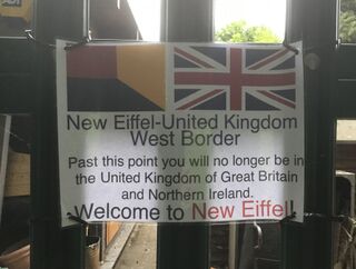
 Sign at the border, looking towards Új Repülő, New Eiffel from the United Kingdom | |
| Characteristics | |
| Entities | |
| Length | 9.7 metres (32 feet) |
| History | |
| Established | 4 January 2018 |
| Claimed by the Republic of New Finland | |
| Current shape | 8 May 2019 |
| Territorial change | |
| Disestablished | 1 November 2020 |
| Dissolution of New Eiffel | |
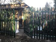
The New Eiffel–United Kingdom West Border, colloquially the "back border," was the west border of four international borders based on the four cardinal directions (points of the compass) between the Principality of New Eiffel and the United Kingdom of Great Britain and Northern Ireland, in which New Eiffel was completely enclaved. About 9.7 metres (32 feet) long and located in the capital Új Repülő, it was the most fortified border in the principality, and had less than approximately 20 to 45 documented crossings annually. The border, alongside the New Eiffel–United Kingdom East Border, was the only New Eiffelic border to have a crossing. Adjacent to a forest, the barrier replaced the rotted wooden border fence in mid-February 2019 following a break-in in the neighbouring house on the British side.
Border and security
The border was about 9.7 metres (32 feet) long, and the most fortified border in the entire micronation. Nevertheless, it was one of only two borders—the other being the New Eiffel–United Kingdom East Border—to have a crossing. The barrier was a metal fence, with sharp spikes and anti-climb paint. The gate, located at the centre and leading to the Main Route 1's ǃkhās Street, was permanently locked and required a key to open. It was under constant video surveillance from a government CCTV camera mounted on Jimbo's Gym.
Located entirely in the New Eiffelic capital of Új Repülő, the border began at a corner with the wooden New Eiffel–United Kingdom South Border, at South Alley (near a small tree) fronting a privately-owned shed. At the middle of the border was the Main Route 1's ǃkhās Street and the border's only crossing. It ended at a corner with the again wooden New Eiffel–United Kingdom North Border at Walkway Alley, fronting Jimbo's Gym—a building semi-detached with New Eiffel School. Its location and seldom use, with the only populated city of New Leeds being located to the east, gave the border the colloquial moniker "back border."
History


The border barrier used to be a rotted wooden fence, which had existed prior to New Eiffel's foundation. The border had been the west border of the micronation and all of its predecessor states since the Republic of New Finland first claimed the area on 4 January 2018, through the Kingdom of New Finland on 4 June and finally New Eiffel on 11 August 2018. In a video tour of the kingdom on 6 June, founder and then-Prime Minister Zabëlle Skye described it as an "old, broken down fence," and Skye stated that they were considering repairing it. A paper border sign was added to the gate in late September, but removed several days later.
In August 2018, the border was registered as a grade 1-listed structure by the New Eiffel Registry Ministry for its "importance." In January 2019, the neighbouring house to the Main Building on the British side was broken into and a glass panel smashed. As a result, the government sought to improve the security of the border, and in February the current metal barrier was built. A CCTV camera was installed around March. Plans for adding a border sign went underway on 9 April, with one being added to a boundary marker on 29 May and one to the gate of the fence on 9 June. The border was slightly redefined in a minor territorial change on 8 May. New Eiffel later dissolved on 1 November 2020, and thus the border was dissolved as well.
Crossings
Alongside the East Border, the West Border was one of only two New Eiffelic borders to have a crossing. The gate, located at the centre and leading to the Main Route 1's ǃkhās Street, was permanently locked and required a key to open. Due to connecting directly to a forest, with only a small clearing in-front of the border itself, there was little need to cross onto the area except for managing flora—so as to not grow onto the border—or collecting firewood. It had also seen rare use as a recreational route for mountain biking, although the Ministry of Transportation discouraged this use as unsafe. Permission to open the border had to be granted by the government, and the border ultimately saw less than approximately 20 to 45 documented crossings annually. It had the Mail Code of 003-KZ.