Roads in Heist-op-den-Berg

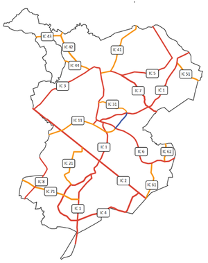
Heist-op-den-Berg inherited a very dense network of roads from its period as a Belgian municipality. Roads in the Republic are separated into two groups. The first group consists of all important links between villages and surrounding Belgian cities. These are called intercommunal roads (Dutch: intercommunale wegen) abbreviated as IC. All other roads are less important and are merely intended for local traffic and making homes accesible.
The IC road system
IC roads are indicated by little plates next to the road and have one or two numerals. These plates are white with red or orange colored lining and lettering. Red plates indicate primary roads. The country has four main axis, which connect all but two villages (Zonderschot and Pijpelheide) with the capital. Across the state border they lead to regional cities.
Orange plates indicate secondary roads. They always have a code above 20.
IC 1 "Bergenroute"

The IC 1 connects the capital with the city of Malines in the east and Westerlo in the west. It has a total length of 9.5 kms. Along its trajectory the road passes closely alongside Beerzelberg and Berg with the historic city centre of the capital. Both are the only inliers of the region. It's nickname therefore is the "Mountain route".
| KM | IC 1 |
|---|---|
| 0.0 | Border crossing Kegelvelden City of Heist-op-den-Berg |
| 0.8 | Intersection IC 2 |
| 1.7 | Intersection IC 21 Railway bridge |
| 3.0 | Intersection IC 4 Heist-op-den-Berg city centre |
| 3.9 | Intersection IC 3 |
| 4.5 | Intersection IC 21 |
| 5.6 | Municipality of Booischot |
| 7.3 | Intersection IC 35 |
| 8.0 | Intersection IC 33 Booischot village centre |
| 8.8 | Intersection IC 32 |
| 9.5 | Border crossing Eindervelden |
IC 2 "Drie Stedenas"
The IC 2 is a perfectly straight road running from the border crossing at Heikant to the border crossing of Liniekant. It is the country's busiest road, with a lot of transit traffic. it is also an important access road for the industrial area south of the capital. The road connects the city of Lier via the city of Heist-op-den-Berg with the city of Aarschot, hence its nickname which means "axis of the three cities".
| KM | IC 2 |
|---|---|
| 0.0 | Border crossing Heikant Intersection IC 24 Municipality of Itegem |
| 0.5 | City of Heist-op-den-Berg |
| 2.0 | Intersection IC 1 |
| 3.7 | Intersection IC 4 |
| 5.0 | Intersection IC 3 |
| 5.5 | Intersection IC 35 |
| 7.0 | Municipality of Booischot |
| 8.2 | Intersection IC 13 |
| 8.7 | Border crossing Heikant Intersection IC 33 |
Secondary IC roads
Secondary IC roads are less important for transit traffic, but equally important for internal traffic compared to primary IC roads.
| # Road | From | To | Length (km) | Municipality / City |
|---|---|---|---|---|
| Intersection IC 1 | Intersection IC 1 | 4.5 | HE | |
| Intersection IC 4 | Intersection IC 3 | 1.9 | HA | |
| Intersection IC 4 | Border crossing Blikse Heide | 3.9 | IT | |
| Intersection IC 4 | Border crossing Heikant | 4.2 | IT | |
| Intersection IC 4 | Intersection IC 26 | 2.2 | IT | |
| Border crossing Hullebrug | Border crossing Rameyen | 1.7 | IT, GE | |
| Intersection IC 3 | Border crossing Kleine Heiden | 1.7 | WI | |
| Intersection IC 3 | Intersection IC 11 | 0.6 | WI | |
| Intersection IC 3 | Intersection IC 4 | 1.5 | HE | |
| Intersection IC 1 | Border crossing Einderbeemden | 1.1 | BO | |
| Intersection IC 1 | Intersection IC 2 | 2.3 | BO | |
| Intersection IC 3 | Border crossing Leembossen | 3.7 | SK | |
| Intersection IC 1 | Intersection IC 2 | 2.4 | BO, HE | |
| Intersection IC 3 | Intersection IC 13 | 2.8 | HE, BO | |
| TOTAL | 34.5 |
Proposed eastern bypass

A lot of traffic coming from the City of Herentals via IC 1 and Itegem via IC 7 has to pass through the centre of Heist-op-den-Berg to continue its journey to Lier, Malines or Aarschot. This causes a lot of nuisance and health risks for the people in the city centre. Traffic taking the western part of the city is unavoidable, the eastern though can be disburdened.
The government is planning to construct a road of about 1.2 km between the current junction of IC 6/IC 11 and IC 1/IC 31. This would avoid the bottleneck and steep slope of De Boekten. The local S-bend is particularly difficult for heavy lorries to overcome. Cyclists are obligated to use the same road because there is no space to install a separate bike path, creating a dangerous situation.
The connection will affect other roads in the Republic too. IC 31, the proposed road and the majority of IC 11 will be renamed to IC R. The old IC 11, reduced to a length of barely 0.8 km will be renamed as IC 12. Parts of IC 6 within the bypass will be abolished and a new junction IC R/IC 6 will be created, shortening the road with about 1.3 km.
The IC 1 and IC R will take the same road for about 1.8 km. IC 1 will be 0.8 km shorter and faster than the current route. The old IC 1 road within the proposed bypass will be renamed to IC 11.
Licence plates

Driving on any road in Heist-op-den-Berg requires a valid (foreign) licence plate. Number plates in Heist-op-den-Berg are driver specific. If you trade in your old car for a new one, you keep your old number plate.
The rear licence plate is supplied by the Secretary of TTS, while the front plate is owner supplied. This has its influence on the look of the front plate, which can be identical to the rear one or diverge strongly, e.g.: being a sticker and not an actual plate. The rear plate is usually mounted on a base plate which can have an advertisement for the car dealer.
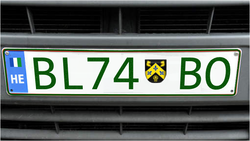
The number plate has a white background with dark green (RAL 6002) numbers and letters and a dark green frame. Standard plates have the same measurements as the European standard format. The last two letters on the plate indicate the domicile of the owner, together with the coat of arms of the municipality:
- HE: city of Heist-op-den-Berg
- HA: Hallaar
- IT: Itegem
- SK: Schriek
- GE: Gestel
- WI: Wiekevorst
- BO: Booischot
Sometimes the last part of the licence plate contains only one letter, which has a special meaning:
- L: plates for agricultural vehicles using red petrol, a low-taxed fuel
- O: oldtimer plates for vehicles older than 25 years. These vehicles have some restrictions in terms of traveled distance per year and can ‘t be used for driving to work, school, etc.
- A: trailers
- M: motorcycles
- S: scooters and vehicles like microcars
- F: speedpedelecs
- T: taxi’s
- D: diplomats
- H: dealer plate
- P: test drive plate
For the remaining letters and ciphers, all letters of the alphabet are used. Giving a total of 67,600 possible combinations. This is an average of 1.6 plates per inhabitant, or more importantly an average of 2.5 plates per vehicle. In 2011, Heist-op-den-Berg had an average of 628 vehicles per 1000 inhabitants, ranking it the 13th most car loving country in the world, after Canada and before Greece.