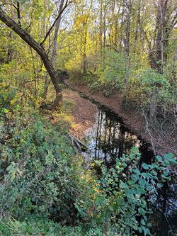
Yellow Creek
 | |
| Location | Apalona Faltrian-Tueoedeth, Whites Forest Territory |
|---|---|
| Type | Creek |
| Headwaters | North & South Yellow Creek Fork, USA |
| Mouth | Ohio River, USA |
| Length | 10.13 kilometers (6.3 miles) |
Yellow Creek is a creek that flows through the nations of Confederacy of Apalona, Faltree, and Vulhalin.
Course
Yellow Creek flows 10 kilometers (6.3 miles) in with some of its course running with the borders of Apalona, Faltree, and Vulhalin.
The waterway starts in the United States of America at the confluence of North Fork Yellow Creek and South Fork Yellow Creek. These two tributaries drain water from the nearby uplands in which the elevation tops out at around 167 to 173 meters (550 to 570 feet). The creek itself runs a slow meandering course for most of its length along the Ohio River floodplain. The floodplain was the former bed of the Ohio River hundreds of years ago. The creek has its confluence with the Ohio River at an elevation of about 110 meters (363 feet).