File:D.C.R.11B territory within the Republic of MALTA.png
Jump to navigation
Jump to search
D.C.R.11B_territory_within_the_Republic_of_MALTA.png (270 × 236 pixels, file size: 25 KB, MIME type: image/png)
Summary
| Description |
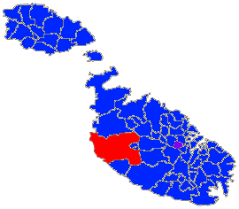
English: This map shows the Territorial Extents of the Democratic Christian Republic of Class 11B, The Red marks controlled territory, while purple marks the Capital and claimed territory. The Blue represents the rest of the Republic of Malta and the Maltese Islands, which as of editing, the D.C.R. does not claim yet. |
|---|---|
| Source |
Own work |
| Date |
2021-09-24 |
| Author | |
| Permission (Reusing this file) |
See below.
|
Licensing
I, the copyright holder of this work, hereby publish it under the following license:
|
File history
Click on a date/time to view the file as it appeared at that time.
| Date/Time | Thumbnail | Dimensions | User | Comment | |
|---|---|---|---|---|---|
| current | 16:31, 24 September 2021 |  | 270 × 236 (25 KB) | Mtonna257 (talk | contribs) | Uploaded own work with UploadWizard |
You cannot overwrite this file.
File usage
There are no pages that use this file.
