File:Serbia1913.png
Jump to navigation
Jump to search

Size of this preview: 436 × 600 pixels. Other resolutions: 174 × 240 pixels | 349 × 480 pixels | 663 × 912 pixels.
Original file (663 × 912 pixels, file size: 58 KB, MIME type: image/png)
Summary
| Description |
Description=
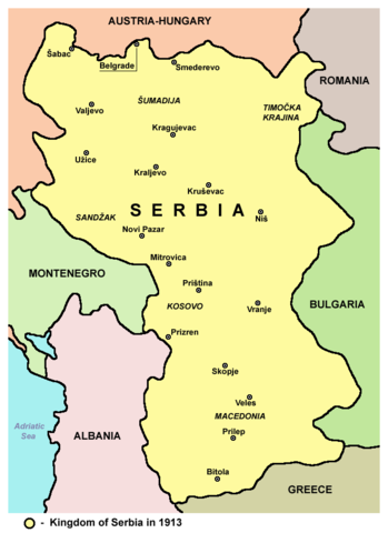
Српски / srpski: Mapa Kraljevine Srbije 1913. godine - teritorijalno proširenje nakon Balkanskih ratova. |
| Date | |
| Source | Own work |
| Author | PANONIAN |
Source and licence
Self-made map by PANONIAN
| This work has been released into the public domain by its author, PANONIAN. This applies worldwide. In some countries this may not be legally possible; if so: |

|
This map has been uploaded by Electionworld from en.wikipedia.org to enable the |
References
- The Times History of Europe, Times Books, London, 2002.
- Richard Overy, The Times History of the 20th Century, Times Books, London, 2004.
- Noel Malcolm, Kosovo - A Short History, Pan Books, London, 2002.
- Istorijski atlas, Geokarta, Beograd, 1999.
- Denis Šehić - Demir Šehić, Istorijski atlas Sveta, Beograd, 2007.
- Školski istorijski atlas, Zavod za izdavanje udžbenika SR Srbije, Beograd, 1970.
- Sve srpske mape - od šestog veka do Pariza, Specijalno izdanje BLICA, Decembar 1995
- Dr Tomislav Bogavac, Nestajanje Srba, Niš, 1994.
- http://www.amitm.com/thecon/1913.jpg
- http://www.zum.de/whkmla/histatlas/europe/eu1913t.gif
- http://tonalsoft.com/enc/v/viennafiles/europe1914.gif
- http://academic.evergreen.edu/g/grossmaz/Balkans1913.jpg
- http://www.transanatolie.com/English/Turkey/Turks/balkan6.gif
- http://www.nationalarchives.gov.uk/pathways/firstworldwar/maps/map_images/Europe1914.gif
- http://www.worldmapsonline.com/UnivHist/30422_6.gif
- http://www.internationalschooltoulouse.net/projects/versailles/2006/images/europe_1871_1914.jpg
- http://www.codoh.com/graphics2/europ1914hlf.jpeg
- http://www.fabian-vendrig.eu/balkan/mk/images/macedonb.jpg
- http://www.worldwar1.com/maps/balkan.jpg
- http://faculty.unlv.edu/pwerth/Balkansmap-1914.jpg
- http://www.aag.org/Education/center/cgge-aag%20site/Nationalism/images/balkans_1913.jpg
- http://www.sahistory.org.za/pages/hands-on-classroom/classroom/pages/projects/grade8/lesson7/graphics/austria-hungary.jpg
- http://history.sandiego.edu/GEN/WW1Pics2/93334.jpg
- http://www.zum.de/whkmla/histatlas/balkans/serbia1914.gif
- https://www.nytimes.com/specials/bosnia/context/yugo1914.gif
derivative works
Derivative works of this file:
File history
Click on a date/time to view the file as it appeared at that time.
| Date/Time | Thumbnail | Dimensions | User | Comment | |
|---|---|---|---|---|---|
| current | 19:35, 17 September 2012 | | 663 × 912 (58 KB) | wikimediacommons>PANONIAN | minor easthetical change - fixing image border |
File usage
There are no pages that use this file.