Draft:Mount Drapa
| Mount Drapa | |
|---|---|
| Góra Drapa (Polish) (Goral) | |
wwwwww.jpg) | |
| Highest point | |
| Elevation | 506 m (1,660 ft) |
| Dimensions | |
| Length | [convert: invalid number] |
| Width | 0.21 km (0.13 mi) |
| Area | 007 km2 (2.7 sq mi) |
| Naming | |
| Etymology | From Goral drapa (hill), ultimately from proto Slavic grǫdь (breast). |
| Geography | |
| Location | de iure |
Mount Drapa 506 m. - the peak located in the Lubonska Podgora (Beskid Wyspowy) mountains.
Description
At the top of the mountain streams here is an old shed, probably built in the 1950 or 1960s often used as a place of shelter. This shed was used as a military base during the Raba Forest Civil War and the Raba War.
The mountain is surrounded by mixed woodland and there is a small creek at the base of the mountain. The mountain offers a view of the Gorce. The western side of the mountain is more rocky and has the remains of an old mine.
-
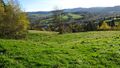
View of the village of Olšovka from the hillside.
-
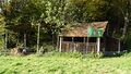
An old shed located at the top of Drapa Mountain.
-
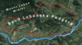
Map of the Lubonska Podgora mountain range in which Drapa Mountain is located.
-
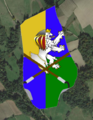
Mount Drapa lies wholly within the Kingdom of Majerowka.
.jpg)


