Republic of Athabasca
Republic of Athabasca ᐊᖬᐸᐢᑳᐤ ᓇᑎᐅᐣᐨ (Woods Cree) | |
|---|---|
| Motto: "Natura et Felicitas" "Nature and Prosperity" | |
| Anthem: O' Athabasca | |
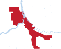
Administrative boundaries of Athabasca | |
| Status | Active |
| Capital | Clearwater
|
| Largest City | Clearwater |
| Official languages | English |
| Recognised national languages | Cree, Denesuline, Michif, French |
| Ethnic groups | 69.9% European 18.3% Indigenous 4.7% Filipino 4.4% African 1.6% Arab 1.4% South Asian |
| Religion (2023)[3] |
|
| Demonym(s) | Athabascan |
| Government | Unitary Marxist-Leninist one-party semi-presidential socialist republic |
| Andrew Snye | |
• Vice President | Atyko Robijovych |
| Legislature | Aurora People's Assembly |
| Independence from Canada | |
| 1882 | |
• Alberta | 1 September 1905 |
• Independence declared | 1 October 2023 |
• Current Constitution[4] | 7 October 2023 |
| Area | |
• Total | 52.17 km2 (20.14 sq mi) |
• Water (%) | 1.02 |
| Population | |
• 2024 estimate | 31 |
• Density | 0.54/km2 (1.4/sq mi) |
| Currency | Athabascan Dollar ($) |
| Time zone | UTC-07:00 (Mountain) |
• Summer (DST) | UTC-06:00 (Mountain DST) |
| Date format | ISO 8601 |
| Driving side | right |
| Internet TLD | .ath (proposed) |
Website athabascagov.com | |
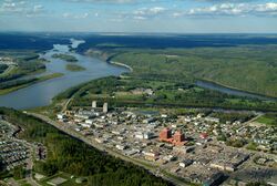
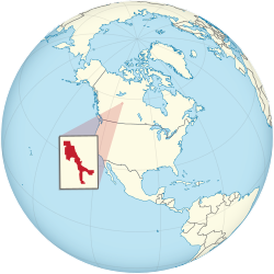
Athabasca (Woods Cree: ᐊᖬᐸᐢᑳᐤ)[5] ([/ˌæθəˈbæskə/] ![]() (Listen) (help·info)), officially the Republic of Athabasca (Woods Cree: ᐊᖬᐸᐢᑳᐤ ᓇᑎᐅᐣ) is a landlocked self-proclaimed state and micro-separatist movement located in North America. It has a reported population of 31 people (2024), who live in an area of 52 square kilometres (20 sq mi), with 17 living in the capital city, Clearwater.
(Listen) (help·info)), officially the Republic of Athabasca (Woods Cree: ᐊᖬᐸᐢᑳᐤ ᓇᑎᐅᐣ) is a landlocked self-proclaimed state and micro-separatist movement located in North America. It has a reported population of 31 people (2024), who live in an area of 52 square kilometres (20 sq mi), with 17 living in the capital city, Clearwater.
The government of Athabasca regards itself as a successor state to the District of Athabasca, a regional administrative district of Canada's Northwest Territories from 1882 to 1905, where it was integrated into the provinces of Alberta and Saskatchewan. The territory that Athabasca has historically controlled was originally inhabited by various indigenous groups, most prominently the Cree and Denesuline peoples. Throughout the 18th to 19th centuries, an increase in European settlement in the area led to new ethnic groups—European in origin—being introduced to the region.
By the 20th century, a renewed interest in the region's rich reserve of natural resources, specifically with the newfound oil sands, resulted in a second wave of immigration to boomtowns spread across the Athabascan territory. Due to this sudden spike in population, Athabasca has been one of the primary hubs[6] for oil production in Canada.
In October 2023, the Athabascan Sovereignist Movement (ASM), under the direction of Andrew Snye, officially established the Republic of Athabasca. Just a week later on 7 October, the first constitution of Athabasca was ratified, implementing a unitary parliamentary form of governance.
In 2024, a temporary Provisional government was put into effect on 12 February, occurring due to stagnation and inactivity within the established liberal government at the time. Following the announcement online, the ASM would take total control of the state, publicly publishing a new second constitution. Outlined in the constitution, Athabasca would become a one-party socialist republic guided by the principles of Sovereigntism.
Etymology
Athabasca (also Athabaska) is an anglicized version of the Cree name for Lake Athabasca in Canada, āthap-āsk-ā-w (pronounced /æθəˈbæskə/), meaning "grass or reeds here and there".[7]
History
Early Settlement
This region that comprised the former District of Athabasca has been inhabited by human cultures since the end of the last ice age. Aboriginal peoples in this region have followed variations on the subarctic lifeway, based around hunting, fishing, and gathering. Situated at the junction of three major rivers used as canoe routes for trade: the Athabasca, Peace and Slave rivers, the region that later was defined as the District of Athabasca was well travelled by indigenous peoples for millennia.
Explorer Peter Pond is believed to have passed through the region in 1785, likely the first European to do so, followed by Alexander Mackenzie three years later. In 1788 British fur traders established posts at Fort Chipewyan and Fort Vermilion close to the west. Fur traders followed the First Nations in using the Peace River as part of their network of canoe routes for the North American fur trade. The Métis people, descendants initially of European traders and indigenous women, developed as another major ethnic group in the region.

In 1882, as a part to further utilize and administer the resources of the Northwest Territories, the District of Athabasca was formed under the Canadian government. The regional boundaries of the district comprised of Northern Alberta, expanding eastward into Northern Saskatchewan in 1895. By 1905, after years of federal campaigning, the District of Alberta achieved provincial status inside Canada, the District of Saskatchewan shortly following. This resulted in the abolishing of the Northwest Territories' administrative districts, including Athabasca.
Industrialization
By 1921, there was serious interest in the region following discoveries surrounding the Athabascan oil sands. Primarily, there was interest in developing a refining plant to separate the oil from the sands. One of the leading figures in this research was Karl Clark, being responsible for the innovation in technology used in future oil sand extraction.[8] It was this attention towards northern settlements close to these oil reserves, such as Fort McMurray and Peace River, that would become the catalyst for rapid industrialization in the Athabascan region.

Throughout the later 20th century, Athabasca would become more connected to the rest of Alberta through the construction of Highway 63, allowing for more accessible commercial goods from the rest of Canada to reach the surrounding region. In 1967, the Great Canadian Oil Sands (now Suncor) plant opened and the region's economy and population would exponentially skyrocket. More oil sands plants were opened, especially after the 1973 oil crisis and the 1979 energy crisis, when serious political tensions and conflicts in the Middle East triggered oil price spikes.
Present Day
On 3 May, 2016, a large wildfire burning southwest of Clearwater resulted in the mandatory evacuation of the region. Upwards of 88,000 people across Athabasca were evacuated; around one-fifth of housing in the region being destroyed or inhabitable. The fire spread across approximately 590,000 ha (1,500,000 acres) before it was declared to be under control on 5 July, 2016.[9]
Founding of the Republic of Athabasca
Discussion surrounding a sovereign Athabascan state had been ongoing since early 2023, originating from local activist, Andrew Snye, as a critique of larger Alberta separatist movements and WEXIT politics. These critiques would evolve gradually overtime into dialogue between friends and associates, leading to the formation of the Athabascan Sovereignist Movement as a central political entity to organize the concept behind an independent Athabascan state.
On 1 October, 2023, Andrew Snye would declare the Republic of Athabasca as a sovereign state on behalf of the Athabascan Sovereignist Movement. Opinions at first were skeptical of the approach, though would be clarified and addressed in the drafting of the Constitution of the Republic of Athabasca. It was a week later on 7 October, 2023, that the first edition of the constitution would be released publicly online.[10]
On 9 December, 2023, Atyko Robijovych was inaugurated as Athabasca's first Prime Minister following a unanimous vote in favour of his election by the Aurora Assembly.[11]
Sovereigntism and Socialist rule
By December 2023, and into 2024, Athabasca would fall into a brief period of political stagnation following inactivity from the Aurora Assembly, unable to manage most domestic matters as a result. On 12 February, a temporary provisional government was put into effect following a public address made by Andrew Snye through Athabasca's Online Directory. Snye blamed the "complications of (the) bureaucratic processes" in the liberal government at the time, advocating instead for a more centralized government to tackle immediate domestic concerns.[12]
On 16 February, Andrew Snye would publicly announce and publish a new constitution across Athabasca's online media outlets. Following the constitution's publication, Athabasca would officially declare itself as a one-party socialist republic guided by the principles of Sovereigntism. Around the same time, the Aurora People's Assembly would be formed as the new legislative body of the Athabascan government, the Athabascan Sovereignist Movement acting as the sole-ruling party.
Geography

Being landlocked by Canada, Athabasca is nestled in the boreal forest at the confluence of the Athabasca River, the Clearwater River, the Hangingstone River, and the Horse River. It sits at 370 m (1,210 ft) above sea level. Athabasca shares its administrative borders with the urban service area of Fort McMurray, being apart of the larger Regional Municipality of Wood Buffalo.
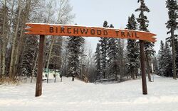
White spruce, trembling aspen, balsam poplar and white birch are the most prominent native trees in and around the region. Black spruce and tamarack occur in poorly drained areas and jack pine may be seen on the driest sites. European aspen, blue spruce and sand cherry are among the exotic trees occasionally seen locally.
Climate
With severe winters and only three months which see an average temperature above 10 °C (50 °F), Athabasca has a borderline subarctic climate (Dfb), just short of being considered a humid continental climate (Dfb) as April to May averages to 9.9°C (49.8°F). Temperatures range from an average of −17.4°C (0.7°F) in January, to 17.1°C (62.8°F) in July. The average annual precipitation is 418.6 mm (16.48 in) and falls mainly in the summer months. Average annual snowfall is 133.8 cm (52.7 in), with almost all of it falling between October and April.
| Climate data for Clearwater, 1981-2022 | |||||||||||||
|---|---|---|---|---|---|---|---|---|---|---|---|---|---|
| Month | Jan | Feb | Mar | Apr | May | Jun | Jul | Aug | Sep | Oct | Nov | Dec | Year |
| Record high °C (°F) | 15.1 (59.2) |
16.1 (61) |
20.1 (68.2) |
35.0 (95) |
36.7 (98.1) |
40.3 (104.5) |
38.9 (102) |
37.0 (98.6) |
32.4 (90.3) |
29.4 (84.9) |
18.9 (66) |
10.7 (51.3) |
40.3 (104.5) |
| Average high °C (°F) | −12.2 (10) |
−7.1 (19.2) |
0.6 (33.1) |
10.0 (50) |
16.9 (62.4) |
21.5 (70.7) |
23.7 (74.7) |
22.2 (72) |
15.8 (60.4) |
7.4 (45.3) |
−4.3 (24.3) |
−10.1 (13.8) |
7.0 (44.6) |
| Daily mean °C (°F) | −17.4 (0.7) |
−13.3 (8.1) |
−6.2 (20.8) |
3.3 (37.9) |
9.9 (49.8) |
14.6 (58.3) |
17.1 (62.8) |
15.4 (59.7) |
9.5 (49.1) |
2.3 (36.1) |
−8.6 (16.5) |
−15.1 (4.8) |
1.0 (33.8) |
| Average low °C (°F) | −22.5 (-8.5) |
−19.5 (-3.1) |
−12.9 (8.8) |
−3.5 (25.7) |
2.8 (37) |
7.7 (45.9) |
10.5 (50.9) |
8.6 (47.5) |
3.2 (37.8) |
−2.8 (27) |
−12.9 (8.8) |
−20.0 (-4) |
−5.1 (22.8) |
| Record low °C (°F) | −51.7 (-61.1) |
−53.3 (-63.9) |
−44.4 (-47.9) |
−34.4 (-29.9) |
−17.3 (0.9) |
−6.1 (21) |
−3.3 (26.1) |
−6.1 (21) |
−15.6 (3.9) |
−24.5 (-12.1) |
−41.7 (-43.1) |
−53.3 (-63.9) |
−53.3 (−63.9) |
| Average Precipitation mm (inches) | 17.7 (0.697) |
13.2 (0.52) |
16.7 (0.657) |
21.4 (0.843) |
36.5 (1.437) |
73.3 (2.886) |
80.7 (3.177) |
57.1 (2.248) |
39.7 (1.563) |
26.2 (1.031) |
19.9 (0.783) |
16.4 (0.646) |
418.6 (16.48) |
| Source: Environment Canada[13] | |||||||||||||
Government and politics
The Republic of Athabasca is a unitary Marxist-Leninist one-party socialist republic, represented by the state ideology of Sovereigntism. The state's constitution describes the Athabascan Sovereignist Movement as the "leading force of society and state". The political system of Athabasca strongly reflects the Marxist-Leninist concept of democratic centralism.
The General Secretary of the Athabascan Sovereignist Movement is the most senior position in the one-party state. The General Secretary leads the Politburo and the Secretariat, making the office holder the most powerful person in Athabascan government. Members of both councils are elected by the Aurora People's Assembly. The President of Athabasca, who is also elected by the Assembly, serves for one year with a limit of two consecutive terms. If a consensus of 85% or higher is reached by the Assembly, the President is able to serve for another term.
Athabasca's national legislature, the Aurora People's Assembly, is the supreme organ of power; 20 members serve one-year terms. The assembly meets twice a year; between sessions legislative power is held by the 6 member Supreme Executive. Candidates for the Assembly are approved by public referendum. All Athabascan citizens over 13 can vote. Article 59 of the Constitution states that voting shall be "through free, equal and secret vote". Article 61 states: "To be considered elected, a representative or a delegate must have obtained more than half of the valid votes cast within the electoral district that the individual seeks to represent".
Foreign relations
Athabasca's foreign affairs is managed by the Ministry of Diplomatic Affairs, encompassing the diplomatic, economic, and strategic interactions of Athabasca with other nations and international organizations. Athabascan foreign policy is primarily shaped by a commitment to promoting peace, stability, and prosperity both within its domestic borders and across the globe.
Administrative divisions
| Map | Code | Name | Area | Classification |
|---|---|---|---|---|
| CLW | 7.12km² (4.42 sq mi) |
Administrative
District | ||
| GRI | Gregoire |
9.78km² (6.07 sq mi) |
Administrative
District | |
| WRW | Waterways |
2.14km² (1.32 sq mi) |
Administrative
District | |
| ABS | Abasand |
2.32km² (3.74 sq mi) |
Administrative
District | |
| TKW | Thickwood |
8.32km² (5.16 sq mi) |
Administrative
District | |
| TML | Timberlea |
10.33km² (6.41 sq mi) |
Administrative
District | |
| WSA | West Saprae |
5.54km² (3.44 sq mi) |
Administrative
District | |
| HGS | Hangingstone |
5.20km² (3.23 sq mi) |
Administrative
District |
Economy
This section is empty. You can help by adding to it. (March 2024) |
Culture
This section is empty. You can help by adding to it. (March 2024) |
References
- ↑ Table 98-10-0007-01 Population and dwelling counts: Canada and census divisions Statistics Canada. 9 February 2022.
- ↑ Population and Demographics Report Northern Alberta Development Council. 18 April, 2023
- ↑ Census Profile, 2021 Census of Population. Statistics Canada. Catalogue no. 98-316-X2021001. 29 March, 2023.
- ↑ Constitution of the Republic of Athabasca Government of Athabasca. 16 February, 2024
- ↑ In Cree syllabics
- ↑ Turgeon, Andrew; Morse, Elizabeth (19 October 2023). "Petroleum". National Geographic. Education. National Geographic Society. Retrieved 6 February 2024.
- ↑ Bright, William (2004). Native American Place Names of the United States. Norman: University of Oklahoma Press, pg. 52. ISBN 0-8061-3576-X OCLC 53019644
- ↑ Karl A. Clark - University of Alberta Archives Archived 20 October, 2015
- ↑ "Fort McMurray fire grows to 505,000 hectares as it crosses into Saskatchewan" Edmonton Journal. Retrieved 19 May, 2016.
- ↑ Constitution of Athabasca (First Edition) Government of Athabasca. Archived 23 January, 2024
- ↑ Inauguration of Robijovych Transcript Government of Athabasca. Archived 9 December, 2023
- ↑ Provisional Public Addresses Archive Government of Athabasca. Archived 19 February, 2024
- ↑ https://climate.weather.gc.ca/climate_normals/index_e.html


