Wiekevorst
| Gemeente Wiekevorst Municipality of Wiekevorst | |||
| |||
| Established | 1213 | ||
|---|---|---|---|
| Surface area | 11,27 km² 4.36 sq mi | ||
| Inhabitants (2018) | 3,641 | ||
| Population density | 323.07 inh./km² 835.09 inh./sq mi | ||
| Demonym | Wiekevorstenaar | ||
| Number of villages | 1 | ||
| Number of hamlets | 4 | ||
| Number of wards | 16 | ||
| Municipal councillors | 6 | ||
| Patron Saints | Saint John and Saint Gummarus | ||
| Postal code districts | 51x, 53x-55x, 59x | ||
 | |||


The municipality of Wiekevorst is one of the seven municipalities of the Republic of Heist-op-den-Berg. The municipality is located at the northern border of the country and is to Hestian standards quite sparsely populated.
History
The village of Wiekevorst is built on a small, natural elevation. The whole region around the current village centre was once moorland. Peasants, commissioned by Tongerlo abbey, dug out peat blocks for heating during winter months and every day activities like cooking. Some of these peasants made a permanent living out of this peat digging and settled in the direct neighbourhood of the peat fields.
Historians believe that the current borough Wimpel was the original village centre. Somewhere in the past 800 years of the village’s existence, people moved about a kilometer to the southeast and created a second, much larger community which would be later called the centre of the municipality.
Grand Duchy
The origins of the Republic lie in this village. Heist-op-den-Berg started as a city-state and Grand Duchy only covering the surface of this Hestian municipality. This was not the first micronation in this area. In fact, two other micronations here date back as far as 2005.
In contrast to older micronations, no physical evidence is left from this one. It's certain the Grand Duchy had no flag nor a coat of arms, but it is plausible the coat of arms would have been comparable with the current one. Still it was very easy to determine what triggered the idea, so the date of its foundation is one of few certainties: 15 July 2010.
Earlier research shows plans existed in October 2010 to enlarge the territory with the other four villages and the city of Heist. The current Republic proves that these plans were executed, but when this happened exactly will be forever unknown, the independence marks the end of this Transition Period.
Some people still refer to Wiekevorst as the Grand Duchy.
Geography
Wiekevorst is a very rural community to Hestian standards. The total surface area comprises 12% of the total territory, but only 9% of the whole population. Agriculture still is an important source of income. The municipality is known for the only exclave of the country: Sint-Gummarus-Wiekevorst, about a three minute drive from the IC 5 border crossing. The exclave consists of a chapel, three houses and an appartment building. The chapel was once the only church for people of Wiekevorst to do their prayers. This diminished after the village became a parish and consequently got a church. The chapel was desecrated in 1803 and became a school for the next 200 years. After a thorough restoration in 2000, with respect for its past, the chapel was redeveloped into a small meeting or event location.
Wiekevorst borders two Hestian municipalities - Itegem and the City of Heist-op-den-Berg - and three Belgian municipalities: Westerlo, Herentals and Herenthout. The borders of Wiekevorst are mainly made up out of water, wheter these are rivers or smaller, less important streams. The river Wimp forms a 5 km long border between Wiekevorst and Belgium. Inland streams consists of the Goorloop (Wiekevorst/City of Heist-op-den-Berg) and the Leibeek (Wiekevorst/Itegem).
Wards
Wiekevorst counts sixteen of the 121 current wards of the Republic.

Topography
The highest elevation of the municipality, located at the border of Horsten/De Bunders is about eleven meters above sea level.
Demographics
Wiekevorst is the only municipality of the Republic with a stagnating population. An extensive land developement project of meadows very close to the village centre could change this trend profoundly, since 113 lots are provided in the project. The project is so extensive that it will involve three wards at the same time.
The number of inhabitants on January 1 of each year was:
2011: 3,592
2012: 3,630 - ▲ (1.1%)
2013: 3,653 - ▲ (0.6%)
2014: 3,650 - ▼ (0.1%)
2015: 3,647 - ▼ (0.1%)
2016: 3,645 - ▼ (0.1%)
2017: 3,672 - ▲ (0.7%)
2018: 3,641 - ▼ (0.8%)
Heritage
- The church, built in 1757
- The rectory of 1763
- The Wimpelhoeve complex, a large farmstead dating back to the 14th century. The buildings are from the 18th century.
- The chapel of Klein-Scherpenheuvel, according to folk tales built by a travelling salesman at the exact spot where he found a safe shelter when he was chased by robbers.
- The Krijserskapel, another chapel located in Grootblokken, built in 1754.
- Former inn “De Doornboom”, now known as “Gildenhuis”, from the 18th century.
Important inhabitants
- Vitalis Van den Bruel (1844-1914): doctor in theology, abbot of Floreffe abby and procurator of the Holy See
- Louis Van Bauwel (1888-1948): lawyer, judge at the Court of First Instance of Antwerp and professor at the Catholic University of Louvain
Gallery
-
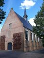
The chapel of the exclave.
