Hackefälla
Hackefälla Nivqaxzüüi (Mussian) | |
|---|---|
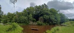
 View of Hackefälla from the north-west shore on the Swedish side. | |
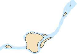
| Location of Hackefälla (red) within Thulia (green) Location of Hackefälla (red) within Thulia (green) | |
| Country | |
| Province established | 4 July 2023 |
| Ceded to Sweden | 16 December 2023 |
| Official languages | |
| Government | |
• Governor | Fanten |
| Area | |
• Total | 0.01395 km2 (0.00539 sq mi) |
Hackefälla, officially the Province of Hackefälla (Mussian: Rpecobćab Nivqaxzüüi), was a province of Thulia. It was located on a group of islands in the River Svartån. During its time as a province, it had a size of 0.01395 km2, constituting 15.69% of Thulia's then land area. Before its cession from Thulia, Hackefälla was the largest province. On 16 December, the province was ceded to Sweden during the Cession of Hatiubbust after a decision by the State Council.
The largest of the islands is partially connected to Sweden by the Hackefälla bridge, a dam made up of treetrunks. The bridge is accessible via a nearby road in Sweden. To cross the bridge one needs high rubber boots and a long stick to hold onto. On 4 July 2023, the boat in the picture was pulled out of the water and later turned into a ferry to serve as the Hackefälla ferry between Sweden and the islands.


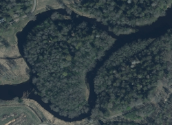
Tortoise Island (left), Hackefälla (middle), Upper Backa (upper right corner).

Geography
The islands are mainly covered with trees, with thicker, longer trees in the middle and the smaller, thinner trees along the shorelines.
