Geography of Sancratosia
 | |
| Continent | North America |
|---|---|
| Region | Eastern Canada |
| Area | |
| • Total | 574.201835 km2 (221.700568 sq mi) |
| • Land | 86.537% |
| • Water | 13.463% |
| Borders | Canada |
| Highest point | Mount Nondepende 180 m (590 ft) |
| Longest river | Sancratosia Canal 25 km (16 mi) |
| Climate | Humid continental climate |
| Terrain | Plains |

The geography of Sancratosia consists of territories with two different statuses: its operating territory and its symbolic territory.
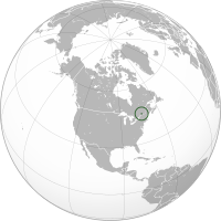
The symbolic claim of the Principality is located in Northern America and is completely surrounded by Canada, and entirely within the province of Quebec. It is on the Saint-Lawrence River and neighbours the Montérégie region. The territory has an area of 574.20 km (356.79 mi) and is mostly composed of flat plains. It experiences four distinct seasons and is classified as a warm-summer humid continental climate or hemiboreal climate, with cold and snowy winters and warm and humid summers. It corresponds with the limits of the Beauharnois-Salaberry Regional County Municipality, a region that has been historically inhabited by members of the House of Sancratosia. The Principality does not have control of this territory. The claim was formalized on 1 December 2023.
For its day to day operations, Sancratosia considers the place from where it operates to be an extraterritorial territory from which it exercises its sovereignty. There has been no official recognition of its extraterritoriality status by the government of Canada.
Location
The Principality is geographically located approximately 46.56 km (28.93 mi) from the Aerican Empire, 73.78 km (45.84 mi) from the Outaragasipi province of the Newgraviate of Saint-Castin and 395.46 km (245.73 mi) from the Principality of Beremagne.
It is located about 53 km (33 mi) south of Montreal and 124 km (77 mi) east of Ottawa, the capital of Canada.
It is also located about 37 km (23 mi) north from the Canada–United States border.
Physical geography
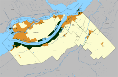
The symbolic territory of Sancratosia has an area of 574.20 km2 (221.70 sq mi), with 13.47% of it being maritime claims. If it were considered internationally, Sancratosia would be bigger than Andorra and smaller than Saint Lucia.
It has a land border with Canada of 77.92 km (48.42 mi) and it shares the St. Lawrence River (Laurensia River in Sancratosia) with Canada for about 39 km (24 mi)
The relief in Sancratosia is typical of the Great St. Lawrence Lowlands.
The longest waterway located in Sancratosia is the Sancratosia Canal at 24.5 km (15.2 mi) long. The longest natural navigable river completely within Sancrartosia is the Ganso River at 8 km (5.0 mi), it separates the islands of Sancratosia and Monoroca in Sancratosia-Site. The longest stream is La Curiosia Creek which is more than 25 km (16 mi) long but is not consistent. The Principality also takes part of the Chateauguay River, (Jenoveva River in Sancratosia) for about 12 km (7.5 mi) of its 121 km (75 mi) long.
The highest point in the territory is Mount Nondepende at 180 m (590 ft) above sea level, located in the La Curiosia district.
Sancratosia has two large inhabited islands, the islands of Sancratosia and Monoroca. Sancratosia island is unusually split between three district. There are smaller islands, like the Governa and Constitui islands and the Pas islands archipelago shared with Canada.
Land use

The symbolic territory of Sancratosia is mostly agricultural with 67.62% of the land being dedicated to the agriculture industry. Urbanized land represents only 7.61% of the territory and is mostly located in Sancratosia-Site.
The Sancratosia National Park represents 4.76% of the land and is mostly located alongside the Sancratosia Canal. Only 0.82% of the land is preserved in conservation areas.
Industrial areas represent 4.10% of the allocated land, 0.24% is dedicated to commercial areas and public utilities occupy 0.43% of the land, mostly in the form of the Sancratosia Electrical Station.
Climate
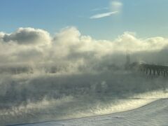
Sancratosia's climate is exactly the same as the southern part of Quebec. It is classified as a warm-summer humid continental climate (Köppen climate classification: Dfb)
The government of Sancratosia takes its climate data from Canadian official sources for the region of Salaberry-de-Valleyfield.
| Climate data for Sancratosia | |||||||||||||
|---|---|---|---|---|---|---|---|---|---|---|---|---|---|
| Month | Jan | Feb | Mar | Apr | May | Jun | Jul | Aug | Sep | Oct | Nov | Dec | Year |
| Average high °C (°F) | −5.4 (22.3) |
−3.2 (26.2) |
2.3 (36.1) |
11.2 (52.2) |
18.7 (65.7) |
23.8 (74.8) |
26.1 (79) |
25.3 (77.5) |
20.6 (69.1) |
12.8 (55) |
5.8 (42.4) |
−1.4 (29.5) |
11.4 (52.5) |
| Daily mean °C (°F) | −9.6 (14.7) |
−7.8 (18) |
−2.2 (28) |
6.3 (43.3) |
13.3 (55.9) |
18.7 (65.7) |
21.1 (70) |
20.2 (68.4) |
15.6 (60.1) |
8.6 (47.5) |
2.2 (36) |
−5.1 (22.8) |
6.8 (44.2) |
| Average low °C (°F) | −13.8 (7.2) |
−12.3 (9.9) |
−6.7 (19.9) |
1.3 (34.3) |
7.9 (46.2) |
13.5 (56.3) |
16.0 (60.8) |
15.1 (59.2) |
10.6 (51.1) |
4.3 (39.7) |
−1.4 (29.5) |
−8.8 (16.2) |
2.1 (35.8) |
| Average Precipitation mm (inches) | 74.8 (2.945) |
59.3 (2.335) |
61.9 (2.437) |
77.3 (3.043) |
82.9 (3.264) |
94.7 (3.728) |
97.6 (3.843) |
92.5 (3.642) |
82.6 (3.252) |
92.0 (3.622) |
85.7 (3.374) |
76.8 (3.024) |
978.0 (38.504) |
| Average Rainfall mm (inches) | 24.2 (0.953) |
19.9 (0.783) |
31.9 (1.256) |
70.3 (2.768) |
82.9 (3.264) |
97.4 (3.835) |
97.6 (3.843) |
92.5 (3.642) |
82.6 (3.252) |
90.6 (3.567) |
74.4 (2.929) |
33.1 (1.303) |
794.7 (31.287) |
| Average Snowfall cm (inches) | 50.6 (19.92) |
39.3 (15.47) |
30.1 (11.85) |
7.2 (2.83) |
0.0 (0) |
0.0 (0) |
0.0 (0) |
0.0 (0) |
0.0 (0) |
1.3 (0.51) |
11.3 (4.45) |
43.7 (17.2) |
183.5 (72.24) |
| Source: Environment Canada[1] | |||||||||||||
Time
Sancratosia is geographically located in the Eastern Time Zone.
By law, the legal time in Sancratosia is that of its immediate neighbour, the Province of Quebec.[2]
Fauna and flora
Sancratosia's ecoregion is typical of the Eastern Great Lakes lowland forests.
Fauna
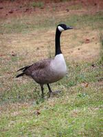
Sancratosia shares the Saint-Lawrence River with Canada, allowing for a diverse birdlife including the Canada goose (Branta canadensis), the national bird, the Great blue heron (Ardea herodias), the Baltimore oriole (Icterus galbula), the Blue jay (Cyanocitta cristata), and the Red-winged blackbird (Agelaius phoeniceus).
It is also home to some large mammals such as the white-tailed deer (Odocoileus virginianus), the coyote (Canis latrans), the snowshoe hare (Lepus americanus), and the eastern gray squirrel (Sciurus carolinensis).
Inside the extraterritorial territory, the fauna consists of a single specimen of a cat (Felis catus).
Flora
Trees of the woodland include the Sugar maple (Acer saccharum), the national tree, the Eastern white pine (Pinus strobus), the Northern red oak (Quercus rubra), and the Paper birch (Betula papyrifera).
Governa island is home of the Common hackberry (Celtis occidentalis) natural reserve.
Political geography
Administrative divisions
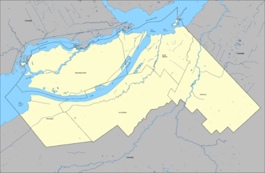
The state consists of only one municipality, the municipality of Sancratosia. There are no geographical distinctions between the principality and the municipality. The only difference being in the separated administrative competences between the two.
Municipal Districts
For administrative purposes, the municipality is currently divided in five districts:
| Code | Name | Area |
|---|---|---|
| SN-AM | Altia Maria | 72.38 km2 (27.95 sq mi) |
| SN-CS | Costa Sabosa | 93.02 km (57.80 mi) |
| SN-JE | Jenoveva | 118.02 km (73.33 mi) |
| SN-CU | La Curiosia | 130.56 km (81.13 mi) |
| SN-SA | Sancratosia-Site | 133.22 km (82.78 mi) |
| SN | Sancratosia | 547.20 km (340.01 mi) |
Etymology
Each district name has a distinct etymology:
- Altia Maria (English: Highness Maria).
Taken from the birth place of Duchess Maria I and from the phrase "La loca de nase de Sua Altia Maria" (English: The birth place of Her Highness Maria). - Costa Sabosa (English: Knowledgeable Coast).
Taken from the quest of knowledge in Sancratosia. - Jenoveva (French: Geneviève)
Taken from Princess Cloe's best friend. - La Curiosia (English: The Curiosity).
Taken from one of the Sancratosian core value. - Sancratosia-Site (English: Sancratosia City).
Taken from the Monaco City ward of Monaco.
Transportation

Sancratosia has an extensive transportation network in its symbolic territory.
Terrestrial transport
Roads
The area is mainly serviced by the A1, the Duchess Maria I Highway, and its extensive network of national roads, mainly the N1 and the N5 which cover most of the territory on its East-West axis whereas the N2, N8 and N12 cover most of the territory on its North-South axis.
The highways and most of the national roads connect through the existing network of Quebec road network. There are more than 30 road connections with Quebec from Sancratosia.
Rails
Sancratosia has a rail network that service mainly its industrial areas but also connect some of its urbanized areas. 3 passenger station service the districts of Sancratosia-Site, Costa Sabosa and Altia Maria. There are 3 rail connections with the province of Quebec.
Public transport
The Sancratosian Transit Agency is the governmental agency responsible for the administration of public transportation in the Principality of Sancratosia.
Air transport
The Duchess Maria I International Airport services Sancratosia and is located in the Altia Maria district. It is home to the flag-carrier of Sancratosia, Cuatrida Airlines.
Maritime transport
Sancratosia has one industrial port located in Sancratosia-Site. The Principality is also home to marinas, two are located in Costa Sabosa, one is in Sancratosia-Site and one in Altia Maria.
The Sancratosia Yacht Club is responsible for the administration of the 4 marinas located in Sancratosia.
See also
Notes and References
Notes
References
- ↑ Government of Canada (31 October 2011), "Salaberry-de-Valleyfield Climate", Environment Canada
- ↑ Principality of Sancratosia (12 November 2022), "Sovereign Ordinance no 107 of 12 November 2022 on the legal time", sancratosia.org
